


When sky-gazing on a clear night, have you ever wondered what exactly you’re looking at? The soft glow of planets, stars, and spacecraft may seem similar at first glance, but they do have some distinctive features. To the naked eye, planets emit a steady shine, while stars seem to twinkle — and both rise and set as the night progresses. Satellites, meanwhile, typically move in slow, steady, and straight paths and may flare in brightness as the Sun reflects off them.
Every satellite you see in our skies has a purpose, and this purpose must be defined before it is built, launched, and integrated into a constellation. Whether designed for communications; positioning, navigation, and timing (PNT); or remote sensing, a satellite’s mission dictates critical decisions regarding size, structure, power supply, sensor payloads, and orbital configurations. As J.P. Ploschnitznig, senior principal application engineer at Ansys, puts it: “We don't say, ‘build the best system, put it up there, and see what it can do,’ we say, ‘what's the mission and what do you want from that sensor once it’s in orbit?’”
The demand for secure, high-speed global connectivity, precise location services, and high-resolution Earth observation continues to increase, driving significant advancements in satellite technology. With increasing global interest and commercialization of space, there has been a shift in approach involving the deployment of proliferated low Earth orbit (LEO) satellite constellations. Increasingly, the industry is relying on these smaller, networked systems that provide persistent coverage and resilience. This growth is not without challenges, and satellite developers must overcome spectrum management and system integration hurdles — no matter the type of satellite they are developing.
Communications and Positioning, Navigation, and Timing Satellites
The satellite communications market is expanding rapidly, but faces challenges such as congestion and competition for radio frequency (RF) spectrum in LEO and geostationary orbit (GEO), the risk of interference and orbital congestion due to mega-constellations, and the diversity of transmission requirements across various applications. As a specific example of a common challenge, Laila Salman, Ansys principal application engineer, says that the communications of multiple satellites in one area can face interception or interference if operating at the same frequency. Addressing these issues requires continuous innovation in communications technology.
Free-space optical (FSO) communication satellites, for example, are emerging as a promising solution, offering high-bandwidth, low-latency transmissions that are resistant to RF jamming. FSO uses light to wirelessly transmit data over long distances. However, FSO satellites require precise beam alignment and face performance limitations in adverse weather conditions.
Another major advancement is the development of software-defined satellites (SDS), which allow dynamic reconfiguration of frequencies, power allocation, and coverage areas to meet changing mission needs. Hybrid architectures that integrate RF and optical communications while linking constellations in different orbits are also being developed to ensure uninterrupted global coverage and operational redundancy.
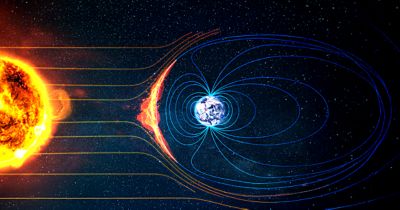
PNT satellites, which were once primarily defense-oriented, now underpin critical services across telecommunications, logistics, and autonomous systems. Despite their growing importance, they face vulnerabilities due to jamming and spoofing, which can disrupt or falsify Global Navigation Satellite System (GNSS) signals. Traditional PNT architectures rely heavily on a limited number of satellites, making them susceptible to malicious activities or system failures. In addition, degraded environments such as urban canyons, subterranean locations, and heavily forested areas pose significant challenges to signal integrity.

Remote Sensing Satellites
Remote sensing satellites play a crucial role in environmental monitoring, disaster response, defense and intelligence applications, and commercial mapping. The sheer volume of data generated by high-resolution sensors presents another challenge, necessitating advanced onboard processing and high-bandwidth downlinks. The choice of sensors further complicates system design, as different missions require electro-optical, synthetic aperture radar (SAR), or thermal imaging technologies.
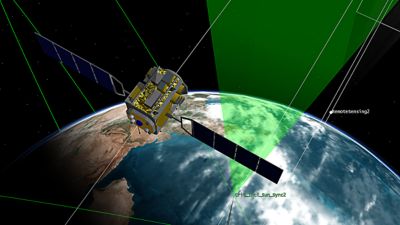
Electro-optical and infrared (EO/IR) sensors are widely used for high-resolution imaging in the visible and infrared spectrums, supporting applications in agriculture, forest fire detection, intelligence gathering, and early warning systems. Hyperspectral imaging takes this capability further by detecting unique spectral signatures (reflected radiation wavelengths), making it valuable for material analysis, environmental monitoring, and counter-camouflage operations. SAR is an advanced remote sensing technology that uses radar signals to create high-resolution, detailed images of the Earth’s surface. SAR can penetrate cloud cover, smoke, fog, adverse weather conditions, and darkness by using radio waves to create detailed ground images. SAR has become indispensable for surveillance and reconnaissance, offering all-weather day-and-night imaging capabilities.
Artificial intelligence (AI) is also playing a growing role in enhancing remote sensing capabilities. The next generation of satellites will incorporate AI-driven edge processing, meaning they can process more data on board. This would enable real-time anomaly detection, object classification, and automated tip-and-cue operations. These capabilities will reduce reliance on ground stations, improve response times, and enhance operational efficiency, particularly in tactical environments. To achieve those goals, AI models need clean training data, which can be a challenge. One way Ansys is helping its customers in the area of AI is Project Loch Ness, a complimentary, comprehensive training and validation dataset that features a range of synthetic SAR imagery and supporting information.
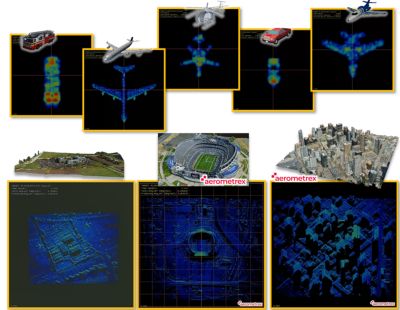
Images from Project Loch Ness. The top row shows vehicle data and the bottom row shows scene data.
Effectively Managing the Complexities of Satellite Design
For all its emptiness, space is full of challenges. Decisions made on Earth will determine the success of a mission taking place far from Earth’s surface. At their core, these decisions come down to a few primary factors. "Power, space, and weight — these are scarce resources on a satellite,” says Pat North, principal R&D engineer. “System engineering needs to balance the requirements with the resources.”
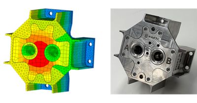
System engineering employs simulation to construct a virtual model of a satellite and run trade studies to determine the benefits of different components and optimize their design to meet specific mission objectives. With simulation, engineers can accurately determine how a satellite will perform in its operational environment — all from the comfort of their desks.
Due to these benefits, Ansys software has long played a major role in satellite development. Digital mission engineering tools, such as — formerly the Satellite Tool Kit — enable designers to model and explore sophisticated satellite options in real time. For example, STK software enables engineers and satellite operators to identify targets for observation; study a satellite in a model orbit at a specific altitude; understand when, and how often a target will be visible to the satellite; and determine what level of resolution could be obtained with different kinds of sensors and optics.
"STK software lets you fly many scenarios and ensure you meet the mission requirement,” Ploschnitznig says. “STK allows you to simulate any sensor, visualize the coverage, assess the sensor performance, and generate synthetic data to validate your digital engineer options."
STK software can be propagated with real-world geographic and geospatial reference data for modeling missions so a developer can see where a satellite will be, how fast it will be moving, what it can see or sense from that position, and more. Orbits, altitudes, sensor types — all the parameters modeled by STK software can be manipulated, enabling a designer to model the satellite’s ability to deliver on mission goals.
"Ansys STK software offers developers a sandbox for creativity that you simply don't get from a lot of legacy tools,” says North.
Not only can STK software enable such a comprehensive analysis, but it also provides engineers with essential visualization tools. "STK software produces beautiful videos that are technically critical to enabling people to understand what's going to happen in space — where the sensor is going to look and what it's going to be able to see — without ever launching into space,” Ploschnitznig says.
Beyond the STK software, Ansys provides a wide range of other simulation tools and materials libraries that can help engineers and satellite operators model and refine their designs to achieve mission goals:
- Ansys HFSS high-frequency electromagnetic simulation software facilitates the design and refinement of antennas, such as phased array antennas, and can predict antenna system performance when it is integrated into the satellite payload.
- Ansys RF Channel Modeler high-fidelity wireless channel modeling software enables designers to analyze high-frequency signal propagation effects to model anticipated RF performance.
- Ansys Lumerical software, Ansys Zemax OpticStudio optical system design and analysis software, and Ansys Speos CAD integrated optical and lighting simulation software, designers gain access to a full complement of tools for designing and refining optical systems.
With systems like Ansys ModelCenter model-based systems engineering software and Ansys optiSLang process integration and design optimization software, engineers can create integrated engineering workflows that help explore trade-offs and identify options based on specific parameters. Such workflows enable engineers to use these simulation solutions together, passing data from one tool to another. This provides insight into the effects of a change in one area — say, the satellite's altitude — on other aspects of the satellite itself and its ability to meet the mission's goals. With Ansys simulation software, engineers and operators can ask — and answer — important questions about their design before building a single prototype or launching the satellite.
Insight Into Satellite Growth: Enabling Global Connectivity and Intelligence
Satellite communications, PNT, and remote sensing form the foundation of the modern global connectivity, precision navigation, real-time situational awareness, and resilient space-based infrastructure serving both civilian and defense applications. However, the increasing threats posed by spectrum congestion, cyber vulnerabilities, and adversarial counterspace activities demand continued innovation and investment. The future of these capabilities will be shaped by hybrid architectures, AI-driven automation, and an increased reliance on proliferated satellite constellations.
When looking at the night sky with a new appreciation for all the complexities these satellite systems have it's clear that to maintain a strategic advantage, governments and commercial entities must prioritize the development of next-generation satellite communication, resilient PNT solutions, and advanced remote sensing platforms. Investments should focus on security, redundancy, and interoperability, ensuring that critical data remains accessible, protected, and actionable in any operational environment. The ability to deliver timely, accurate, and secure information will be a decisive factor in global competition, shaping the future of operations, commercial enterprises, and everyday life. Simulation software will play an important part in achieving these goals. "In simulation, you’re only constrained by the laws of physics, not budget,” says North.
Learn More
Get a sneak peek of the upcoming Ansys documentary, Simulating Space.
“STK software lets you fly many scenarios and ensure you meet the mission requirement. It allows you to simulate any sensor, visualize the coverage, assess the sensor performance, and generate synthetic data to validate your digital engineer options.”
— J.P. Ploschnitzing, Senior Principal Application Engineer, Ansys