“I still say, ‘Shoot for the Moon; you might get there.’”
— Buzz Aldrin
On Friday, Oct. 4, 1957, Sputnik 1 became the first artificial satellite to be successfully placed into orbit around Earth. Despite its relatively small stature, Sputnik 1 helped launch a new era of missions in lunar and cislunar space — that is, the volume of space between Earth and the Moon — that extends through today.
The famed Apollo program, for instance, included the goals of carrying out a scientific exploration program of the Moon and developing the human capability to work in the lunar environment. To achieve these goals, the Apollo program ran missions between 1967 and 1972 that expanded our knowledge for lunar missions and inspired future generations of space innovators.
In more recent history, the Artemis program has also come onto the scene, quickly establishing its place as one of the most important lunar missions. Artemis is a human spaceflight program aiming for the Moon but reflecting a much broader mandate and unique emphasis than its predecessors.
Artemis is focused on long-term progress, including sustained infrastructure on the Moon that would involve a base camp and regularly sending crews up. Artemis also differs because it uses previously unexplored orbital options like distant retrograde orbits (DROs). It also relies on international cooperation, including the collaboration between global governmental and commercial space organizations.
With each successful mission, the space industry has continuously proven humanity’s ability to transverse lunar and cislunar space. However, this does not mean that the journey is simple. Ensuring that such missions succeed without a hitch involves careful planning and precise, specialized trajectory design, which is only becoming more difficult as the space industry grows.
Lunar and Cislunar Navigation
At its simplest, lunar and cislunar navigation involves finding the right path to get you to your destination. While the engines firing a rocket may propel you to a destination, the tracking and navigation processes will direct you to your goal.
Historically, all space mission tracking has been achieved from the ground. This direct ground-based tracking involves a network of ground antennas that communicate with a spacecraft while also observing its location.
As any mission operator would tell you, ground-based tracking is not perfect. First, there’s the persistent challenge of having limited ground-tracking resources, which will only become more restricted due to the growing number of missions on the horizon.
Second, various physical effects associated with ground-based tracking cause cyclical injections of uncertainty in the orbital solution. Figures 1 and 2 show spikes of uncertainty over a one-month period (that is, one revolution of the Moon around Earth) for ground-based line-of-sight tracking via range and Doppler.
To address the shortcomings of ground-based tracking, researchers are investigating other forms of tracking for the space industry.
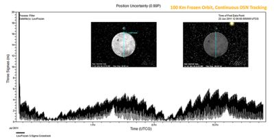
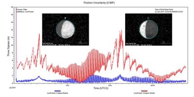
Figures 1 and 2. Simulation images showing line-of-sight tracing from Earth to the Moon (via range and Doppler).
Space-Based Relays
One alternative to ground-based tracking is a space-based relay. In fact, this approach has seen successful demonstrations, as with China’s Queqiao relay satellite deployed to track and communicate with the Chang’e 4 lander on the far side of the Moon.
As seen in Figure 3, space-based relay tracking (typically achieved via range and Doppler) can potentially provide full coverage of orbits around the Moon. These relays can also aid communications.
Another form of tracking that is currently deployed is space-based optical tracking. This involves one satellite with an optical sensor tracking another satellite by taking pictures that show the subject against a starry background.
One advantage of space-based optical tracking is that the sensor platform has a great deal of movement, which changes the angle at which it observes an object and helps in the orbit determination process. While space-based optical tracking instruments may not be as accurate as their ground-based counterparts in some cases, they may be a better option because they are not subject to weather-related outages.
Moon-Based Ground Stations
One navigation possibility that is not yet in use is tracking from a lunar ground station, such as those proposed by the Artemis program. These stations would enable ground tracking from the Moon instead of from Earth. Tracking lunar orbiters from a lunar ground station would benefit from changing geometry in the way that Earth-orbiting satellites are tracked from Earth ground stations.
Non-Navigation Signals
Passive radio-frequency (RF) tracking is an example of using a non-navigation signal to enable cislunar and lunar navigation. To understand how passive RF tracking works, figures 4 and 5 show a satellite in orbit about L1 and its downlink to two ground stations on Earth’s surface. The dual collection of the downlink facilitates the generation of time difference of arrival (TDOA) and frequency difference of arrival (FDOA) measurements. Using these measurements, a satellite can be tracked using its own downlink.
Optical Navigation
With optical navigation (which is distinct from optical tracking), a satellite takes pictures that help it navigate, often autonomously. In Figure 6, a satellite takes pictures of both Earth and the Moon from the vicinity of L1, which it will then use to determine the direction toward Earth and the Moon and thus its own position. This relatively cost-effective technique can be used alone or to augment other tracking data, depending on mission requirements.
Global Navigation Satellite Systems
Another navigation possibility is to use existing global navigation satellite system (GNSS) signals, such as the global positioning system (GPS). Although existing GNSSs were designed to work in the near-Earth environment, it has proven to be helpful in space missions, even at great distances from Earth.
One example of this is the Magnetospheric Multiscale Mission (MMS) and its specially designed GPS receiver. MMS explored the use of GNSS well above the typical altitude of the GPS constellation and expanded GPS use about halfway to the Moon.
Lunar Navigation Satellite System (LNSS)
Finally, an LNSS design would employ multiple satellites orbiting the Moon. LNSS has the potential to provide high orbit accuracy around the Moon while requiring fewer satellites than GNSSs orbiting Earth.
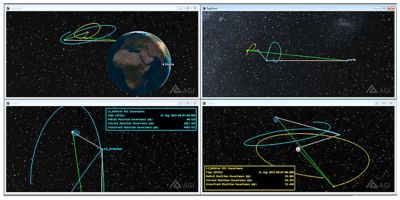
Figure 3. Simulations showing space-based relays in Earth-Moon L2 and Earth-Moon L1.
Further Expanding Into Lunar and Cislunar Space
The future of space is bright. In the coming years, the next Artemis missions are looking to set the stage for the next age of space — and Artemis is not alone in this resurgence. As Jim Woodburn, Ansys Fellow and AGI chief orbital scientist, says, NASA’s Commercial Lunar Payload Services (CLPS) program is carrying a few payloads to the Moon that are of interest to “navigation buffs.” This includes the Lunar GNSS Receiver Experiment (LuGRE), which will be launched on the Firefly Blue Ghost Mission 1, “Ghost Riders in the Sky,” and the Next Generation Lunar Retroreflector (NGLR).
There’s no psychic ball that will tell us the future of space. However, if you asked experts in the industry to make educated guesses, they’d tell you a few things.
“I think the future of navigating in space is more interesting and exciting than ever,” says Woodburn. “Some of the biggest trends in cislunar space, beyond an explosion of general interest, seem to be the desire for more spacecraft autonomy — taking advantage of increased computational power and the promise of onboard artificial intelligence and machine learning (AI/ML) algorithms to lessen the need for ground contacts and the push for a position, navigation, and timing (PNT) system in the lunar regime.” This lunar PNT system would benefit satellite navigation, lunar surface navigation, and lunar communication by bringing GPS-like capabilities to the region near the Moon.
Ansys also has a role to play in this future. First, as with space missions themselves, Ansys simulation software is constantly growing and adapting. For example, Woodburn shares the new Ansys capability to use landmarks on the Moon for optical navigation simulation analyses, such as those involving satellites in orbit around the Moon.
“The enablement of digital engineering workflows holds tremendous promise for accelerating the exploration, development, and commercialization of space,” says Woodburn. “Unlike the terrestrial environment, where digital engineering practices are an accelerator for program development, in space, digital engineering practices are essential to the ability to iterate on designs that cannot be tested in the field.”
Using simulation, engineers can model the most common challenges that space missions face in a digital environment that accurately reflects actual mission conditions — helping us safely navigate to the Moon and back.
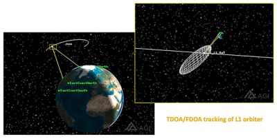
Figures 4 and 5. Simulation images showing passive radio-frequency (RF) tracking.
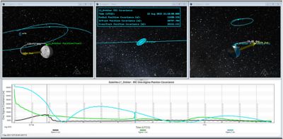
Figure 6. A simulation example of the optical navigation of an L1 orbiter.
Learn More
Learn how Ansys Orbit Determination Tool Kit (ODTK) orbital measurement processing software can support mission design and planning.
Just for you. We have some additional resources you may enjoy.
“I think the future of navigating in space is more interesting and exciting than ever.”
— Jim Woodburn, Ansys Fellow and AGI chief orbital scientist
