Fans of mythology or Dungeon and Dragons (D&D) may have heard of wyverns before. Commonly described as creatures akin to dragons but having only two legs, wings, and a pointed tail, wyverns are fearsome creatures that are a source of danger for many a story or D&D adventuring party.
But what does this have to do with space? Instead of a monster taking to the skies, Wyvern is using satellites and hyperspectral imaging to reveal what they call the invisible truths of planet Earth. The team’s “ultimate mission is to provide data about Earth that will enable a more sustainable future for humanity,” says Callie Lissinna, Verification and Validation Lead and Co-Founder of Wyvern.
Today, with its up-and-running Dragonette constellation, the company can collect high spatial resolution, commercial hyperspectral imaging data from low Earth orbit (LEO). Wyvern then provides this reliable, high-quality data to experts in a wide range of industries who are addressing some of today’s biggest challenges.
For instance, consider our climate crisis. Hyperspectral data shows what’s really happening on Earth’s surface, which is an essential tool for better managing both the causes and symptoms of climate change. One such cause is greenhouse gas emissions, which Lissinna says future generations of their satellites will be able to detect and measure in Earth’s atmosphere. Hyperspectral data can also enable the early detection of, for example, gas leaks in remote pipelines, enabling engineers to fix these leaks and minimize the emissions entering our atmosphere. That’s not all, either. Lissinna also notes that hyperspectral data can detect many types of climate change imagery, such as changes in bodies of water over time, the composition of plant species in specific areas, and more.
Another key use of hyperspectral data will be in the agriculture industry. Here, David Miller, Mechanical Design Lead at Wyvern, shares how their work can help evaluate environmental conditions that affect crop health and yields. Other relevant uses in this industry include optimizing resource allocation by determining exactly where water or nutrients are needed, observing land cover changes, and monitoring the health of key species. This is all incredibly important work because, as Lissinna says, “we’re going to need to feed 10 billion people by about 2050, so we need to know how to best use all of the resources that we have for us on this planet to continue to thrive and live sustainably as time goes on.”
These are just a few of the many potential uses of Wyvern’s space-based hyperspectral imaging data. Using this data, multidisciplinary leaders from all over the world will be able to precisely and accurately monitor changes across Earth’s surface and make informed decisions on sometimes-hidden problems.
Investigating the Dragon’s Horde: Wyvern’s Core Technology
To understand the importance of hyperspectral cameras, we need to take a quick step back. Every material on Earth’s surface has a spectral signature, which Lissinna describes as a fingerprint of its chemical makeup. Hyperspectral imaging breaks down these spectral signatures into small spectral bands. “With these small bands, it’s possible to see the chemical composition of every pixel in the image,” says Lissinna, thereby providing a level of detail that would be impossible in a normal photograph. This results in a heightened ability to detect and classify from these images.
In a little more detail, a typical image camera breaks up the spectrum into three spectral bands (red, green, and blue) and then reconstructs them into full color for the final image. As such, a normal photo would show a field of grass as green, for example. With hyperspectral imaging, the spectrum is broken up into many spectral brands, which reveal extra information. For instance, instead of a green field, the hyperspectral data can use its additional spectral bands to differentiate what areas of the field are lacking water or specific nutrients — and that’s not all. With hyperspectral imaging, you can see things that would be impossible to determine with the naked eye, such as how chlorophyl is expressed in plants.
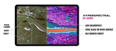
A traditional RGB image compared to a hyperspectral image (Credit: Wyvern Inc.)
Wyvern’s current Dragonette constellation produces hyperspectral imaging data with a 5.3-meter ground sampling distance and 23 unique spectral bands, which enables the identification of unique chemical and physical properties on the surface of the Earth. These images are processed to Level 1B (L1B) by the Wyvern team and converted into a GeoTIFF for better integration into a customer’s existing workflow.
To ensure that are optimized, the Wyvern team trusts Ansys simulation software.
Simulation Is the Glue That Connects All Pieces of the Wyvern Puzzle
Wyvern “uses simulation all throughout our design cycle,” says Miller. This begins with the first step of orbital design and mission planning. Here, the Wyvern team uses Ansys Systems Tool Kit (STK) digital mission engineering software to study potential scenarios to determine the most efficient orbits and plan which satellite is best to take each customer order. “STK software is just completely fundamental to that process,” says Miller.
A following step for the team is to use simulation to optimize the design of their imaging telescopes. This is an imperative part of the process, as can’t be easily fixed if something goes wrong in space. “Simulation is what you need to do to really verify and validate that this thing is going to perform in a space environment,” says Lissinna. With simulation, Wyvern can confirm early in the development process that their designs will and meet requirements. This is particularly important because it’s a long journey from space mission design to deployment, meaning that errors found at later stages can cause extremely long delays.
As for exactly how the Wyvern team turned to simulation software to optimize their design, they use a number of Ansys products. For instance, Ansys Thermal Desktop thermal-centric modeling software performs the thermal analysis of their telescopes. Both Lissinna and Miler emphasize the harsh thermal environment in space, which creates plenty of design challenges. For example, their designs must be able to withstand the heat of being in direct sunlight for half of their orbit, as well as the extreme cold of the dark side of the Earth for the other half of their orbit.
Miller stresses the importance of performing thermal analyses for their hyperspectral telescopes, which are sensitive instruments that need to withstand a challenging environment. “It takes powerful simulation tools to solve the problems associated with that, so Thermal Desktop software is huge for us,” says Miller. “We're running simulations all the time because we have so many different cases to study to figure out how our telescope will perform in a bunch of different conditions."
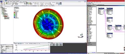
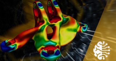
A simulation of a mirror in Ansys Mechanical software. (Credit: Wyvern Inc.)
Ansys Mechanical structural finite element analysis software is able to simulate the structural disturbances on Wyvern’s telescopes. With Mechanical software, Wyvern can study how deformations, even of just a few nanometers, affect their designs. Additionally, they use Ansys Granta Selector materials selection software for the complex material selection process. Granta software enables Wyvern to examine a huge number of potential materials to find the ones best suited for their design constraints. Early in the design process, Wyvern uses Granta Selector to survey the field of available materials for good potential candidate materials: “Granta’s custom material property indices and filters help us narrow down material candidates,” Miller says. Later in the design process, Wyvern uses the extensive material data from Granta in their thermal and structural simulations.
Finally, Ansys Zemax OpticStudio optical system design and analysis software is utilized in designing Wyvern’s optical system, creating their control systems which work to precisely adjust optical components, and combining all their analyses together to see how that will affect the optical performance of their telescopes.
Combining the results of all these different simulations is another key step in their process. “As we're really progressing into design, it's all of these tools working together,” says Miller. By using these powerful integrated tools, Wyvern can have a great deal of confidence in the work that they’re doing, especially as a small team.
Throughout their design and development process, Wyvern also used simulation to increase efficiency, create an automated workflow, and save costs. “As a startup, we always need to be really capital efficient, and simulations can be a way for us to more affordably verify some key functionality,” says Lissinna. Further, as part of the Ansys Startup Program, Wyvern was better able to access the exact tools they needed to develop their products quickly and efficiently.
While the simulation analyses discussed so far occur before Wyvern begins physical prototyping and testing, that doesn’t mean simulation ends at that stage. “As we move further along into testing and then flight, we're again using all these simulation tools to validate our tests,” says Miller. “In flight, we continue to use STK software to plan our capacity and optimize our operations.” To achieve their goal of collecting as many images as possible to positively impact their customers, Wyvern uses STK software to strategically plan and prioritize how to collect all necessary images using the resources they have. This is incredibly important because Wyvern’s customers depend on them being able to take images at the right location and time, which requires constantly monitoring the orbits of their satellites to ensure performance.
Throughout their current workflow and beyond, simulation software is an integral part of Wyvern’s process. As Lissinna says, simulation tools aid in making sure that “all the different pieces of the engineering puzzle fit together” for optimized system performance.
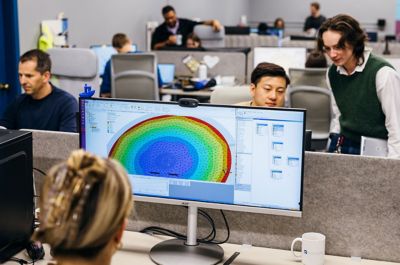
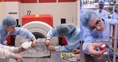
The Wyvern team using simulation software. (Credit: Wyvern Inc.)
Wyvern’s Next Adventures
What we’ve discussed so far is just the beginning of what Wyvern has to offer, and the company is already preparing for its next phases.
One upcoming advancement is the development and launch of the next generation of satellites, which will provide better data with a larger spectral range and higher resolution. This will enable them to detect a wider range of materials and chemical signatures. When these satellites join the existing constellation, Wyvern will be able to take more pictures at a higher frequency as well as offer new products.
Miller shares that future projects for the Wyvern team could include using their hyperspectral data to investigate the Moon or other planets in our solar system. “In the long term, we would love to have satellites in orbit around other planets to help humanity expand into the solar system,” says Lissinna. Throughout it all, the team plans to continue to use simulation to help see their visions for the future come into fruition.
Learn more about how simulation can help you achieve your own goals here.
“Simulation is what you need to do to really verify and validate that this thing is going to perform in a space environment."
— Callie Lissinna, Verification and Validation Lead and Co-founder, Wyvern
