Skip to Main Content

Ansys DME Component Libraries
Bring Mission and Systems Modeling Capabilities to Your Software Solutions

Ansys DME Component Libraries are a collection of development libraries well-suited for creating custom applications that benefit from web-first architectures.

Industry-proven Mission and Systems Modeling Software Development Libraries

Ansys DME Component Libraries are a collection of development libraries well-suited for creating custom desktop applications and web-first architectures. Available in Java and .NET, DME Component Libraries provide foundational mission and systems modeling capabilities in an architecture designed to scale efficiently. 
  • Check icon outline
    Multidomain, time-dynamic modeling environment
  • Check icon outline
    Flexible deployment
  • Check icon outline
    3D Visualization components
  • Check icon outline
    Robust, extensible architecture
  • Check icon outline
    Well suited for creating custom, platform agnostic and highly scalable applications.
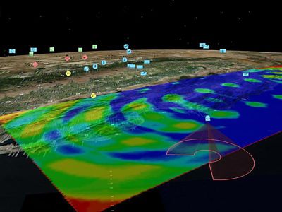
topographic view of map with overlay

Quick Specs

With Ansys DME Component Libraries, developers can directly benefit from decades of mission and system simulation expertise across many foundational capability areas.

  • Real-time Data Support
  • Aircraft/Spacecraft Trajectory Design Tools
  • Spatial Analysis/Coverage
  • Sensor Payloads
  • Geospatial Content Server (GCS) Integration
  • RF, Radar, and Navigation Systems
  • 3D Visualization Engine and CZML Generation
  • Accurate Global Geometry & Terrain
  • Platform Translational and Rotational Motion

Foundational System Modeling Capabilities

Ansys DME Component Libraries offer numerous building blocks, which includes some of the following major capabilities:
  • Various temporal, translational, and rotational coordinate representations and transformations
  • Low and high-fidelity models for the Earth and other celestial bodies, including support for interpolated terrain surface features
  • Geometric primitives representing the kinematics of simple scalars, points, axes, and vectors regarding different frames of reference
  • Simple and advanced propagation algorithms for modeling the motion of land, air, sea, and space vehicles
  • Computation of intervisibility (access) and coverage between assets while accounting for various constraints, including sensor field of view
  • Detailed communications, radar, and navigation system modeling and analysis
  • 3D globe and 2D map visualization of time-dynamic objects and analysis results, either using a web browser (Cesium) or as a control in a desktop application (Insight3D)
  • Dynamic data analysis for near real-time simulation, including data archival and playback
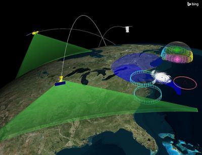
topographic view of map with satellite overlay

Geospatial Content Server

As part of Ansys DME Component Libraries, the Geospatial Content Server provides a comprehensive enterprise solution for hosting, processing, serving, and analyzing terrain, imagery, and other heterogeneous 3D data. In addition to a curated set of terrain, imagery, and 3D models, this geospatial content management system allows the external introduction of various common data types. The data is processed and available within your application for streaming visualization and analytical capabilities such as terrain analysis. Solutions built with Ansys DME Component Libraries can use this geospatial data solution.
  • Check icon outline
    Compile and stream heterogeneous data
  • Check icon outline
    Distributable architecture supports massive datasets
  • Check icon outline
    Interactive content management interface
  • Check icon outline
    Configurable user authentication
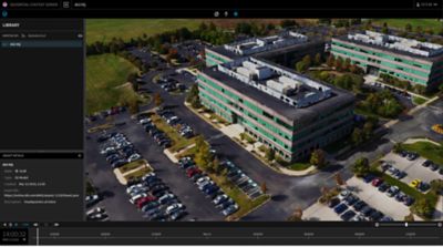
Geospatial Content Server spec sheet image. AGI HQ model in Exton

DME Component Libraries Capabilities

Ansys DME Component Libraries bring world-class mission and systems modeling to software developers

This collection of software development libraries provides developers and systems integrators with fundamental mission and systems modeling capabilities that have been purpose-built to address scalability and performance in support of large enterprise deployments, OEM efforts, and other software solution design architectures requiring scalability and performance.

Components Icon Group


Key Features

Extend your custom software application development to include the following individual libraries capabilities

  • Dynamic Geometry Library
  • Terrain Analysis Library 
  • Spatial Analysis Library 
  • Communications Library 
  • Radar Library
  • TIREM Library
  • Navigation Accuracy Library
  • Route Design Library
  • Tracking Library
  • Orbit Propagation Library
  • Segmented Propagation Library
  • Aircraft Propagation Library
  • Visualization Libraries
  • Geospatial Content Server

This library provides essential architectural elements and algorithms for modeling time, position, and orientation for accurate vehicle propagation, sensor modeling, and intervisibility calculations. Functionality includes:

  • Manipulation of scalars, points, axes, vectors, and reference frames
  • Precise platform positioning and orientation
  • High-fidelity, time-based intervisibility algorithm accounting for apparent motion, including light-time-delay and atmospheric refraction

Employs a highly optimized terrain caching implementation to account for terrain when computing altitudes and performing intervisibility and coverage computations. Utilize terrain and 3D data provided by a Geospatial Content Server.

Enables the computation of asset coverage over point sets, lines, regions, volumes, and dynamic platforms to measure effectiveness using:

  • Flexible gridding algorithms
  • Complex coverage definitions
  • Extensible figures of merit

Provides computational elements for analyzing RF signal transmission between moving or stationary platforms with configurable signal processing and propagation models.

This library extends the capabilities of the Communications Library to provide radar system performance analysis, including:

  • Attitude- dependent radar target cross- section modeling
  • Support for monostatic and bistatic radar systems
  • Multiple target signal returns and intended target identification
  • Metrics for dwell time, integrated signal-to-noise ratio, and probability of detection

Expands the capabilities of the Communications and Radar libraries with loss prediction over irregular terrain and seawater.

Model the GPS constellation using various data formats and configurable receivers to compute the navigational accuracy of terrestrial and spatial points. This library Includes algorithms for:

  • Dilution of Precision (DoP)
  • Navigational accuracy
  • Receiver Autonomous Integrity Monitoring (RAIM)

Using vehicle-specific characteristics, generate trajectories and attitudes for aircraft, ground vehicles, and ships. Functionality includes:

  • Pre-defined route procedures
  • Vehicle attitude modeling
  • Terrain-constrained procedures

Incorporate support for dynamically acquired data using the elements from this library. Integrate processing, visualization, and analysis for the development of decision support, situational awareness, and distributed simulation applications using:

  • Optimized one-point analysis
  • Data filtering and event processing
  • Software transactional memory system
  • Archiving and playback

Provides industry-recognized force model algorithms for numerically propagating satellite orbit state and covariance through any orbit regime including, LEO, MEO, GEO, HEO, and interplanetary missions. Includes impulsive and finite maneuver modeling capabilities.

Supplies architectural elements for computing vehicle trajectories where the manner of propagation changes with time:

  • Performing numerical propagation with arbitrary stopping conditions.
  • Solving for a trajectory by varying initial conditions and other propagation settings subject to arbitrary constraints on the motion and final conditions.

Propagate an aircraft through various maneuvers subject to flight phase performance models and wind effects. With defined aerodynamic and propulsion models, the aircraft’s orientation is determined by assuming coordinated flight.

DME Component Libraries contain robust simulation and systems modeling capabilities enhanced by a collection of visualization library options serving the needs of desktop applications and web-first designs:

  • Cesium LibraryVisualize time-dynamic objects and analysis on a 3D globe or 2D map natively in a web browser. 
  • Insight3D Visualization Library (Windows only)Visualize time-dynamic objects and analysis with this embedded control in your custom desktop applications.

Geospatial Content Server provides a comprehensive enterprise solution for hosting, processing, serving, and analyzing terrain, imagery, and other heterogeneous 3D data.

  • Process and curate varied terrain data sources into a global unified global tileset for hosting 
  • Efficient streaming to client applications using open standards terrain runtime format, Quantized Mesh, avoiding vendor lock-in
  • 3D Tiles, Cesium’s open specification for streaming massive heterogeneous 3D geospatial datasets, is the format of choice for the Geospatial Content serve
Ansys logo on black background
Documentation and Assistance

Further explore the capabilities of Ansys DME Component Libraries by taking a look at the documented help files and getting started resources.

Ansys logo on black background
Explore Code Samples

Find some helpful example applications and code samples on the following GitHub repo.

Ansys Aircraft Simulation
Product Brochure

To learn more about product features and capabilities, download the brochure.

See What Ansys Can Do For You

Contact us today

* = Campo obbligatorio

Grazie per averci contattato!

Siamo qui per rispondere alle tue domande e non vediamo l'ora di parlare con te. Un membro del nostro team di vendita Ansys ti contatterà a breve.

Footer Image