


How many ships are sailing across Earth’s oceans right now?
While this may seem like a daunting question — our oceans have a surface area of around 139 million square miles after all — those in the maritime industry can use the automatic identification systems (AISs) onboard seafaring vessels to identify themselves. As its name suggests, an AIS is used to automatically track ships, as well as for monitoring and data exchange purposes. Many countries and global organizations, such as the International Maritime Organization (IMO), have specific rules mandating the use of an AIS, which enables broad knowledge about human activity across our oceans.
But what if a ship does not comply with these regulations and decides not to share its location via AIS? Ships like these will not appear when using conventional tracking methods and are referred to as dark ships, dark vessels, or dark fleets.
Exploiting this lack of surveillance, dark vessels can participate in illegal, unreported, and unregulated (IUU) fishing practices that harm marine environments, local economies, and global food security. IUU is a widespread issue, with one study finding that 72% to 76% of industrial fishing is untracked.
To combat harmful activities like this, we need an alternative method of tracking — such as using Earth observation satellites. “Earth observation has always been a very important aspect of the space economy,” says Dr. Minda Suchan, vice president of geointelligence at MDA Space. “There are things you can see from space that you don’t have the same perspective of here on Earth.” For example, she shares how dark vessels can be seen and tracked with radar imagery generated by Earth observation satellites, which makes this technology important to many across the globe.
Dark vessels are also only one of many reasons why Earth observation is an important capability. Other industries that can use this technology include mining, forestry, and environmental, such as organizations monitoring the effects of climate change via ice mapping.
No matter the specific use, MDA Space uses its wealth of experience gained from developing world-leading space technology over 50 years and over 450 missions to address these critical global challenges. MDA Space’s expansive work includes partnering for communication satellites, space observation, space exploration, and infrastructure missions. Through this vast, longstanding work, MDA Space can “bridge the gap between the proven and the possible,” says Suchan. One of the proven products that MDA Space develops to push what’s possible is its RADARSAT-2 satellite, which can be used to solve a variety of customer issues, including dark vessels detection and IUU fishing.
Exploring the Benefits of the RADARSAT-2 Satellite
To understand the RADARSAT-2 mission, consider a customer investigating a potential dark vessel in its country. The customer requests an image of a location where it suspects the dark vessel to be sailing at a specific time. After receiving this request, MDA Space will command the RADARSAT-2 satellite, instruct it to collect data to image the target area, receive the data, download the data, analyze and interpret the data, and then deliver actionable insights to the customer — all while maintaining a highly precise orbit, says Lambert.
To generate the data that customers are looking for, RADARSAT-2 relies on a particularly important sensor technology: a synthetic aperture radar (SAR) antenna located at the bottom of the satellite.
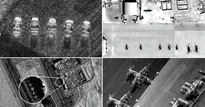
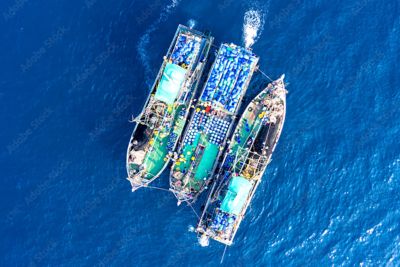
This SAR antenna sends coherent radar signals to the ground and then measures the beam’s reflection after it is reflected back up to the satellite, explains Dr. Casey Lambert, head of RADARSAT-2 mission operations for MDA Space, who is deployed directly at the Canadian Space Agency. This measurement is used to form an image of the area that the satellite is observing, such as the example seen below.

RADARSAT-2 imagery of shipping vessels. Photo courtesy of MDA Space.
SAR is “a very versatile Earth imaging tool” that enables applications you can’t achieve with optical images, says Lambert. For example, SAR can “see” in low-visibility conditions like clouds, smoke, and darkness, observing objects like dark vessels that may otherwise remain undetected. SAR also allows you to observe ground motion and “the small but steady changes that happen through climate monitoring,” says Suchan.
Another benefit of the SAR used by the RADARSAT-2 mission is that it functions 24/7 and can survey large areas at once. “We travel around the world once every 100 minutes,” says Lambert, “so we are able to cover a lot of ground and image large areas of the Earth every single day.” Specifically, these satellites can monitor up to 500-kilometer swath widths, says Suchan.
While the RADARSAT-2 mission is already impressive, MDA Space remains focused on reaching for the stars by constantly optimizing and evolving its services. “We’ve been continually improving on a number of different metrics,” says Suchan. These metrics include increasing the swath width, increasing image resolution, and improving data delivery times.
Another point of progress is the ability to reprogram on-orbit, giving MDA Space the flexibility to meet future mission needs with current satellites in space.
“Being reprogrammable on-orbit allows you the flexibility to change, sometimes even making changes here on Earth to satellites that are already in space,” says Suchan. As part of this, the company is developing MDA CHORUS, MDA Space’s next-generation mission that builds upon and shows the progress and innovation of its proven RADARSAT technologies. MDA Space will use this multisensor satellite constellation to provide improved radar imaging to customers.
Throughout it all, MDA Space turns to simulation software to keep up with its constant improvements and maintain a rapid pace of innovation.
Advancing SAR Satellites With Ansys Simulation
“Simulation is always going to be a critical part of building satellites and understanding how satellites operate in space,” says Suchan. “Simulation is an important aspect of not only understanding what you can do (in the present) but also supporting what you will do in the future and the planning process.”
Take the RADARSAT-2 satellite as an example. The MDA Space team needs to ensure that the satellite is constantly operating at a very high level of reliability to perform its current routine operations. To do so, the team turns to Ansys Orbit Determination Tool Kit (ODTK) orbital measurement processing software and Ansys Systems Tool Kit (STK) digital mission engineering software to help with “operating on a daily basis and running reliably every day,” says Lambert. Simulation software can also help support the constant advancements that are needed throughout the full lifespan of the RADARSAT-2 mission. “In terms of continuous improvement, we’re not able to do anything with the hardware in space,” says Lambert, “but we can improve what we have on the ground.”
To increase its accuracy and efficiency, the MDA Space team once again turned to STK and ODTK software. “Ansys was instrumental in improving the orbit determination products that we were generating for the RADARSAT-2 mission,” says Lambert. “By improving the orbit accuracy, we were able to improve the sensitivity to small ground movement, which is a significant improvement to what we were able to do in the early parts of the mission.” These improvements enabled MDA Space to enhance the value of its products for customers. For example, by improving the orbit accuracy by almost one order of magnitude, MDA Space was able to detect ground movements at the centimeter level.
These developments aren’t static either. MDA Space can make continuous orbit accuracy enhancements from the ground via software updates. The company has also “been able to automate the process of orbit determination using STK and ODTK software,” says Lambert. This resulted in a 50% reduction in computing time and a significant improvement in reliability.

MDA CHORUS is the next-generation Earth observation constellation from MDA Space. Image courtesy of MDA Space.
Simulation software also aids with MDA CHORUS constellation development of dual-band SAR satellites. “When you start moving into constellations, that’s where simulation becomes even more important,” says Suchan.
MDA CHORUS relies on two satellites. The first satellite provides C-band broad-area imagery up to a 700-kilometer swath width. This satellite is trailed by a second X-band satellite that offers a smaller swath width with a higher resolution. The combination of these satellites enables the MDA Space team to use the expansive data collected by the C-band satellite to determine what it may want to examine closer using the X-band satellite.
Optimizing the timing between these satellites and figuring out how to maximize the unique functionality of the dual-band design is where simulation comes in. “Simulation absolutely plays a key role not only in how to manage the different satellites but how to optimize operations between the two satellites,” says Suchan.
Throughout MDA Space’s work, “simulation data allows you to be very efficient, as well as allows you to plan very carefully and maximize the imaging opportunity that you have,” Suchan says.
MDA Space’s Next Steps
One industry trend that will aid in the continuous improvement of MDA Space’s technology is artificial intelligence (AI). AI has “an incredible capability that can affect the full value chain,” says Suchan. This can increase efficiency in MDA Space’s design, production, manufacturing, and analytics processes. Suchan tells us that the MDA Space team is already using AI to build a natural language search for its archives, which contain over a million radar images. This project will help locate data, interpret imagery, and unlock the value of SAR for those without expertise in the area.
By using growing technologies like AI and software-defined satellites, MDA Space is well positioned to continue to lead in the global space economy. “MDA Space has so much opportunity to further expand our role as a trusted mission partner to our customers,” says Suchan.
This growth will be aided by the STEM community, which also shows immense growth. “Talent is always going to be an important part of the space industry and is certainly a core part of MDA Space,” says Suchan. At MDA Space, this talent includes engineers with a variety of disciplines and mindsets who form the heart of the company. These engineers create trusted, complex systems that companies have relied on for over half a century and will continue to power the next stages of the space economy.
Learn More
See how Ansys RF Channel Modeler software extends RF signal analysis.
Just for you. We have some additional resources you may enjoy.
“Simulation is always going to be a critical part of building satellites and understanding how satellites operate in space.”
— Dr. Minda Suchan, vice president of geointelligence, MDA Space