-
United States -
United Kingdom -
India -
France -
Deutschland -
Italia -
日本 -
대한민국 -
中国 -
台灣
-
Ansys is committed to setting today's students up for success, by providing free simulation engineering software to students.
-
Ansys is committed to setting today's students up for success, by providing free simulation engineering software to students.
-
Ansys is committed to setting today's students up for success, by providing free simulation engineering software to students.
-
Contact Us -
Careers -
Students and Academic -
For United States and Canada
+1 844.462.6797

Ansys Digital Mission Engineering (DME) solutions offer exciting new capabilities for the 2024 R2 release, with a focus on expanding support for systems engineers across multidomain mission simulation and engineering analysis. With an emphasis on extending interoperability across Ansys’ portfolio of products, 2024 R2 provides new capabilities for advanced system-level design and analysis, artificial intelligence (AI) capabilities, and streamlined methods for connecting and collaborating throughout enterprisewide organizations. DME tools continue to provide multidomain mission modeling and simulation capabilities to support the needs of cross-disciplined engineering teams and systems integrators and enable organizations to collaborate and operate consistently across the entire engineering life cycle.
Extending Subsystem Design and Payload Performance
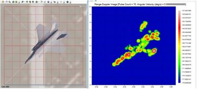
Ansys RF Channel Modeler (RFCM) DME software has expanded its ability to generate channel-level RF signal data to include radar system definitions and workflows, allowing engineers to generate highly accurate synthetic radar data for search/track radar use cases, as well as synthetic aperture radar (SAR) applied to ground imaging applications. With the ability to accurately simulate radar target collections and include the effects of background terrain data and other dynamic objects in a scene, engineers can immediately gain a precise understanding of their radar system performance, as well as leverage large-scale synthetic data results for additional artificial intelligence and machine learning (AI/ML) efforts. Supporting data analysts for event recreation and training and collection planners to optimize expensive test plans, RFCM software also supports the development of AI/ML algorithms that require massive amounts of realistic signature data.
Expanded Accessibility, Usability, and Enterprise Collaboration
Because of streamlined connectivity and interoperability with Ansys electronics desktop tools, engineering teams can easily incorporate their Ansys HFSS 3D high-frequency simulation software phased array antenna designs in Ansys Systems Tool Kit (STK) digital mission engineering software with high levels of fidelity. Easily explore co-site interference across multiple onboard communications systems using STK software and Ansys EMIT software together. These cross-product integrations streamline the ability to incorporate high-fidelity RF design considerations and analyze impacts to mission success.
Using AI for Advanced Analysis
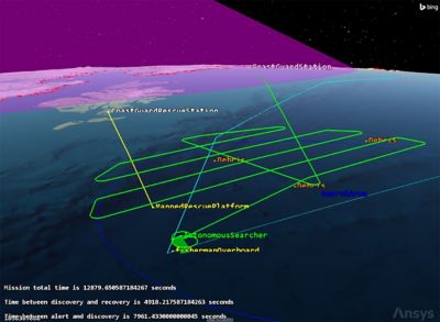
Manned rescue with Ansys Systems Tool Kit (STK) digital mission engineering software
A new AI-based tool, the Ansys Missions AI+ add-on, is now available for orbit analysts in Ansys Orbit Determination Tool Kit (ODTK) orbit simulation software to automatically evaluate the quality of their resulting orbit. Combining tuned models with AI algorithms, the Missions AI+ tool encapsulates decades of subject matter knowledge and experience and allows users to confidently assess the quality of their orbit solutions. Less experienced users also benefit from ODTK software for critical operational needs and to support the safety of flight routines.
Enhanced MBSE Workflows
Model-based systems engineering (MBSE) workflows are enhanced with the STK software’s enterprise offering. Users can easily include state machine representations of their system-level behaviors while leveraging STK software mission simulations and system models to accurately evaluate dynamic performance of the modeled systems involved across any number of simulated conditions or situations. This is all accomplished without the need for additional third-party software applications.
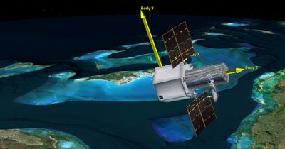
The 2024 R2 release extends subsystem design.
EOIR Performance Improvements
Users will experience noticeably enhanced performance for STK software’s electro-optical infrared (EOIR) sensor simulation capabilities, allowing engineers the ability to more rapidly evaluate modeled sensor performance across simulated conditions and measure results against design requirements. In addition, STK software has expanded EOIR’s data providers to provide pixel-level analysis of synthetic sensor performance so sensor system engineers can evaluate design considerations with greater granularity and speed than before.
Integration With Ansys Minerva Simulation Process and Data Management Software
With this latest release, STK software now natively supports direct integration with Minerva software, so STK software users can open, save, and update STK software mission models and simulations directly to their organizations’ Minerva software ecosystem. With Minerva software’s version control tracking and traceability of design changes and simulation results, organizations will benefit from a streamlined workflow and have a disciplined approach to engineering simulation projects and large-program support. With increased efficiency in engineering design, simulation, and test life cycles, large organizations with distributed teams will benefit from greater collaboration, business process management, and streamlined workflows.
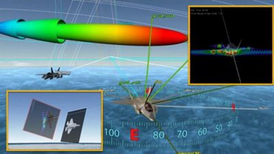
Ansys RF Channel Modeler (RFCM) DME software provides simplified workflows to create complex radar test and evaluation scenarios and leverage high-fidelity synthetic data generation capabilities.
Improved DME Usability
Several usability improvements have been made, with one of the most visible being a new way for users to configure and manage the imposed constraints on their designed systems. A new interface brings a more discoverable, streamlined approach to adding common system-level limitations, such as minimum or maximum ranges, angles, terrain considerations, and other object-specific details that can be configured and used to further define the limitations that need to be included to more accurately represent dynamic system capability and performance.
3D Tile Sets Elevation Support and Lunar Terrain Tiling Capability
STK software’s use of 3D Tiles for streaming terrain information provides users with quick, easy access to high-resolution data. Until recently, these datasets were able to be considered only for aspects of sensor obstruction or intervisibility but now have been extended for use in setting altitude for vehicle routes, trajectories, coverage grid point placement, and other asset placement activity where the elevation information is being supplied by the streaming 3D Tiles dataset directly. For users who need accurate representations of planetary data — specifically for the polar regions, where traditional tiling algorithms prove problematic — the lunar terrain tiling capability overcomes the limitations of a tile map service tiling scheme, which historically results in all the terrain tiles “bunching up” at the poles.
Generating 3D Tiles with the Terrain 2 Tiles utility
Aviator Feature External Ephemeris Enhancements and Low Earth Orbit Operation Support
Aircraft designers often use test data or real-world trajectory information throughout design efforts. Evaluating capabilities of an airframe to conduct specific mission needs, test new payloads, or make any number of engineering exploration efforts can occur throughout the engineering life cycle, even after an airframe has been deployed into operational status. Users now can append ephemeris-driven flight procedures just like any other Aviator procedure type, move and adjust them, and benefit from these profiles being included as part of any Aviator flight profile. This unlocks additional flexibility for aircraft flight profile modeling to include a more robust representation of an aircraft mission plan while maintaining alignment with its real-world performance capabilities.
Ansys Test and Evaluation Tool Kit (TETK) Test and Evaluation Software Markers-by-metric Support
Improvements to STK software’s TETK software track visualization options allow users to denote markers along a vehicle’s route based on metrics of their choosing. These markers can represent the times and locations when certain conditions are met, performance thresholds have been violated, or any other tracked condition that may be outside of specification or tolerance occurs. Additionally, the markers can be configured to change in appearance or style based on sets of conditions for the metric of interest. Changing colors, sizing, labeling, and other aspects of the visual representation can be done to align with metric changes and to call out specific attention to conditions of interest to flight engineers.
Get started now, and join us Aug. 6 to 8 at the Space & Missile Defense Symposium in Huntsville, Alabama.
The Advantage Blog
The Ansys Advantage blog, featuring contributions from Ansys and other technology experts, keeps you updated on how Ansys simulation is powering innovation that drives human advancement.
