


Ansys Systems Tool Kit (STK) digital mission engineering software is known for its aptitude for mission modeling. Having good models to represent a mission’s environment is a critical step that must be done to evaluate system performance and mission success. For any mission involving ground systems (which is all of them) or ground observers (which is many of them), terrain plays an important role in accurately setting up the mission environment. STK software already could ingest many types of terrain and imagery data for visualization and analysis, but the Terrain2Tiles utility expands the realm of possibility.
Convert to 3D Tiles
As of the 2024 R2 release, a new terrain conversion utility is included with STK software. This command-line utility is easy to use and converts terrain from just about any industry-recognized terrain file type — digital elevation models, geographic tag image file formats, JP2s, etc. — to 3D tiles. The 3D tiles format is an open standard designed to describe and organize massive geospatial datasets in a way that is efficient for 3D rendering and analytical querying. When a 3D tileset is loaded into an STK software scenario, the 3D graphics views are rendered with data that scales resolution based on viewing distance. This enables faster rendering because the software does not visualize unnecessarily high-resolution terrain for a given distance. Additionally, Ansys RF Channel Modeler digital mission engineering software requires the operational environment to be represented using the 3D tiles terrain format.
In STK software, a 3D tileset can be applied to any central body and used for analysis, as well as visualization. The Terrain2Tiles utility can convert terrain for Earth, the Moon, and Mars. The tool allows users to specify the vertical datum (also called the height reference) to use when converting terrain data. Considering the proper datum is especially important for accurate representation of any digital terrain model (DTM). The Terrain2Tiles utility supports common height references, including “ellipsoid,” NAVD88, EGM96, EGM2008, and Mars GMM3. Knowing which height reference to specify is typically discoverable through the “read me” file and documentation that accompanies the DTM data. In addition to building a 3D representation of terrain geometry, the utility can bake imagery into the 3D tileset.
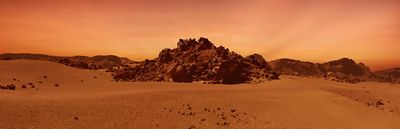
The CTX instrument on the Mars Reconnaissance Orbiter has collected high-quality terrain and imagery data of the Martian surface. Before the Terrain2Tiles utility was available, there was no feasible way to get publicly available terrain and imagery like this USGS Astrogeology Science Center dataset into STK software. Now, the utility allows you to take datasets like this and build a 3D tileset that combines imagery and terrain.
Mars is shown with the default ellipsoid and with overlaid 3D tiles.
Accurately Model Terrain
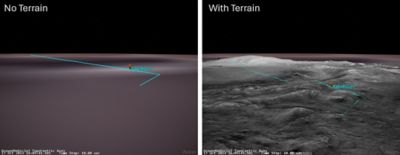
The terrain shown above is near the Martian North Pole. At high latitudes, using the correct vertical datum (Mars GMM3) is critical for accurate modeling. In this specific scenario, the altitude error associated with not taking terrain into account surpasses 600 meters.
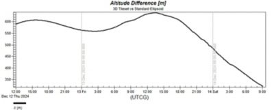
A plot showing the difference in altitude from the Mars ellipsoid to the 3D tileset
In the coming years, we will send astronauts to the Moon to walk its surface for the first time since 1972. A landing region candidate for the Artemis 3 spacecraft is Malapert Massif, a massive lunar mountain with a high point of 5,000 meters. In terrain-filled regions like this, it is important to understand when a moon-walking astronaut will have an unobstructed line of sight back to the lander and various points of interest. Using the Terrain2Tiles utility, a lunar orbiter laser altimeter digital slope map file from NASA’s Planetary Geology, Geophysics, and Geochemistry Laboratory was converted to a 3D tile dataset and inserted into STK software.
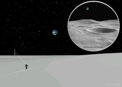
An astronaut moonwalks, and a zoomed-out version of terrain is displayed.
Accurately modeling terrain is critical for understanding the operational environment. Terrain has implications for visibility, system mobility, and route planning, as well as system-of-systems interactions, such as communications. The Terrain2Tiles utility makes it easier than ever to apply terrain in your STK software model. To try out the new utility, you can find this command-line tool in the STK software install bin directory. Learn more about digital mission engineering.