-
United States -
United Kingdom -
India -
France -
Deutschland -
Italia -
日本 -
대한민국 -
中国 -
台灣
-
Ansys is committed to setting today's students up for success, by providing free simulation engineering software to students.
-
Ansys is committed to setting today's students up for success, by providing free simulation engineering software to students.
-
Ansys is committed to setting today's students up for success, by providing free simulation engineering software to students.
-
Contact Us -
Careers -
Students and Academic -
For United States and Canada
+1 844.462.6797

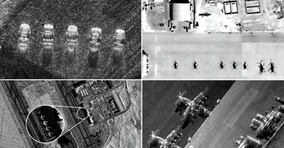
In the ever-evolving landscape of data-driven insights, artificial intelligence (AI) and machine learning (ML) have emerged as critical components needed to augment the limited resources of data analysts who are tasked with exploiting the quickly increasing volume of commercial synthetic-aperture radar (SAR) data. (SAR is an advanced remote sensing technology that uses radar signals to create high-resolution, detailed images of Earth’s surface. Using radio waves to create detailed ground images, SAR can penetrate clouds, darkness, and adverse weather conditions.) As these analysts begin to use algorithms to identify objects in complex SAR images, they will require robust training and validation data to succeed. Access to a comprehensive data lake would enable their success.
Project Loch Ness is an Ansys initiative designed to empower the AI/ML community with a game-changing resource: a complimentary, comprehensive training and validation dataset for a specific ground-based AI/ML target decision scenario. Ansys RF Channel Modeler high-fidelity wireless channel modeling software is used to fill the data lake, and the goal is to provide the community with pure synthetic data for training and validation.
Understanding the Challenge of SAR Image Analysis
The abundance of SAR data may seem like a boon for AI/ML development, but the reality is far more complex. The very data that users would like to exploit cannot typically be used as the primary source of training data, as it often lacks the necessary ground truth information. Further, the data can be riddled with collection system artifacts, which may bias training models.
Many commercial vendors are entering the market, which generates wideband radar images from overhead collection systems, such as satellites or aircraft. Companies like Capella, ICEYE, UMBRA, MDA, and others have demonstrated impressive capabilities to advance the market of Earth resource monitoring. As these companies continue to create higher-resolution data to feed the growing demand for information, the challenge becomes the ability to analyze that data.
The demand for information is in jeopardy of not being met both now and into the future due to the ever-growing volume of data and limited availability of expert personnel. Historically, trained radar analysts would manually pore over radar images, searching for information. Organizations are now turning to AI to assist analysts, but this comes with its own challenges.
Project Loch Ness is a comprehensive training and validation dataset designed to accelerate the development of cutting-edge AI/ML algorithms for ground-based target detection.
Introducing the Project Loch Ness Training and Validation Dataset
Ansys recognizes the urgent need to bridge this gap and empower the AI/ML community with the tools that it requires to push the boundaries of SAR image analysis. That is why we are excited to unveil Project Loch Ness, a comprehensive training and validation dataset designed to accelerate the development of cutting-edge AI/ML algorithms for ground-based target detection.
At the heart of Project Loch Ness lies a curated, documented dataset featuring a wide range of synthetic SAR imagery and supporting information. It covers a specific target decision scenario, providing analysts, researchers, and developers with a robust, consistent, and unbiased foundation to build and validate their AI/ML models.
Discover the Power of Synthetic Data
One of the key advantages of Project Loch Ness is its reliance on well-structured synthetic data created by RF Channel Modeler software. We have generated a diverse array of SAR images that mimic real-world conditions, and the scenes will be fully annotated, providing ground truth: collection geometry information, target type, target position, target orientation, target linear velocity, and target angular velocity.
The dataset consists of:
- Five unique targets for algorithm training
- Three complete scenes (targets embedded) for algorithm validation
- Image and raw in-phase and quadrature (I/Q) data to train and validate your algorithm
- Target elevation variation at 30, 35, 40, 45, 50, 55, and 60 degrees
- Scene elevation variation at 35, 45, and 55 degrees
- Target azimuth variation every 5 degrees (from 0 to 355 degrees)
- Scene azimuth variation every 30 degrees (from 0 to 330 degrees)
- Radar parameters: 10 GHz center frequency, 500 MHz bandwidth (30-cm resolution)
- 1,200 m unambiguous range and cross range (for targets and scenes)
- Less than 1TB total data size
Note: All image and raw I/Q data will be stored in HDF5 format.
Learn more about Project Loch Ness, and join us in this exciting journey as we unveil the true power of synthetic data and demonstrate how it can fuel the next generation of AI/ML solutions for the evolving needs of SAR image analysis.
The Advantage Blog
The Ansys Advantage blog, featuring contributions from Ansys and other technology experts, keeps you updated on how Ansys simulation is powering innovation that drives human advancement.
