-
United States -
United Kingdom -
India -
France -
Deutschland -
Italia -
日本 -
대한민국 -
中国 -
台灣
-
Ansys is committed to setting today's students up for success, by providing free simulation engineering software to students.
-
Ansys is committed to setting today's students up for success, by providing free simulation engineering software to students.
-
Ansys is committed to setting today's students up for success, by providing free simulation engineering software to students.
-
Contact Us -
Careers -
Students and Academic -
For United States and Canada
+1 844.462.6797
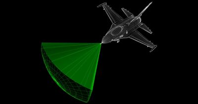
Radar, or the sensors used for locating, recognizing, and tracking objects through the transmission of electromagnetic energy toward them, has been around for decades. This technology is helpful in many ways — for instance, to keep a plane on the right flight path, to help a self-driving vehicle “see” the road ahead, and to predict the weather.
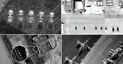
New advancements in radar technology, such as synthetic aperture radar (SAR), make it possible to see the most minute details from space to detect changes to a scene due to environmental factors, such as storms, earthquakes, and even new tire track depressions in soft soil. SAR enables satellites in space to bounce radar signals off the Earth’s surface and interpret those echoes — even through clouds and smoke or in complete darkness — to expose these details.
SAR images are used by the insurance industry for post-natural disaster damage assessment and the construction industry, as well as for environmental research and many other applications. Although SAR may be the most visible manifestation of this technology, inverse synthetic aperture radar (ISAR) imaging, in its ability to use radar imaging to generate a two-dimensional, high-resolution image of a target, also plays a critical role in national security.
In the realization of persistent surveillance, SAR’s newfound success has significantly increased the volume of data that needs to be used to benefit the commercial and national security customer. 2024 R2 Ansys RF Channel Modeler high-fidelity radar data modeling software enables the generation of realistic data that supports advanced analysis concepts, collection planning, and artificial intelligence (AI) algorithm development to find and label objects and activities.
Detailed simulation and synthetic data generation via RF Channel Modeler software is key to understanding how advanced radar-based systems like SAR work in these and other complex scenarios. Recreating them in a simulation environment helps students and novice analysts begin to make connections among what is happening, how objects scatter, and how to exploit the resulting data to advance new applications.
Supporting Advanced Radar Signature Analysis Through Data
One area that RF Channel Modeler software is particularly useful in is radar signature analysis, or understanding how radar signals interact with complex targets to expose the various radar-scattered features of an object or a scene. In this context, radar images are not literal images as generated by electro-optical and infrared sensors. Rather, they are a mapping of radar scattering returns in range and doppler space.
This year, Ansys is enhancing RF Channel Modeler software to create synthetic radar data for any collection geometry and for any geospatial domain to support both SAR and ISAR data generation. Now the software merges the capabilities of Ansys Systems Tool Kit (STK) digital mission engineering and systems analysis software and Ansys Perceive EM simulation software, enabling customers to orchestrate realistic collection scenarios, then generate synthetic radar data (raw I/Q signal data).
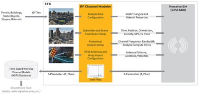
2024 R2 Ansys RF Channel Modeler high-fidelity radar data modeling software flow diagram
The resulting data then can be processed to create all data associated with the collection scenario for frequency response, range profiles, doppler profiles, and wideband radar images. Most importantly, RF Channel Modeler software uses graphics processing unit acceleration to create data in near real time.
Who Benefits From RF Channel Modeler Software?
These fully agnostic synthetic radar data generation capabilities enable RF Channel Modeler software to support a wide range of Ansys customers.
Data analysts benefit from a fully agnostic, multidomain solution. Whether a user recreates a past event or wants to explore a future collection opportunity or concept, RF Channel Modeler software can handle complex, realistic collection scenarios defined by collection system, target, scene or environment, and additional scene contributors.
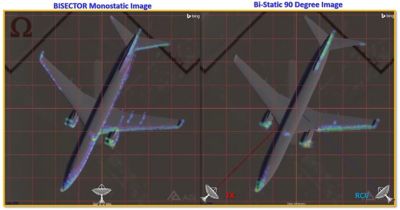
RF Channel Modeler software supports both monostatic and bistatic data generation.
Collection planners can create virtual test environments of existing operational systems and future proposed systems. RF Channel Modeler software enables realistic radar data generation for live test rehearsal — irrespective of range access, costs, collection geometries, measurement precision and position knowledge, and safety — to increase test success and shorten the development cycle.
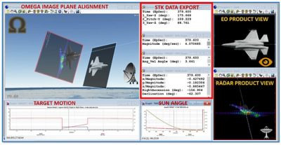
RF Channel Modeler software for virtual test range collection planning
For the artificial intelligence/machine learning (AI/ML) algorithm development community, RF Channel Modeler software addresses several challenges, including:
- Data management: AI/ML enables data analysts to more fully benefit from an exponentially increasing volume of commercial SAR data. Many different algorithms are used to identify desired objects in complex SAR images, but they require an enormous amount of training data. However, this data cannot be used as a primary source of training data. Instead, well-documented test range data must be used.
RF Channel Modeler software addresses this training data deficiency by creating a limitless amount of realistic synthetic radar data over any angle, frequency, bandwidth, or polarization, for example. With this infusion of new data, machine learning can begin to define unique radio frequency characteristics for objects and potential differences between objects.
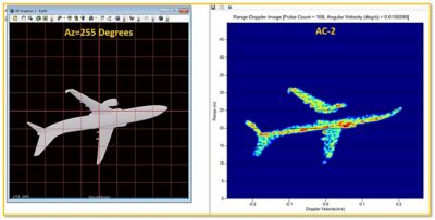
RF Channel Modeler software-generated target data for artificial intelligence/machine learning (AI/ML) algorithm training
- Algorithm validation: Once the algorithm is trained, RF Channel Modeler software creates representative large-scene scenarios with the embedded objects needed to validate object identification performance of the AI algorithm.
Unique sensor characteristics then can be added to the raw I/Q signal data to test algorithm sensitivity or resilience and mitigate undesirable sensor characteristics. In the end, access to unlimited RF Channel Modeler software data ensures success and confidence in AI/ML solutions.
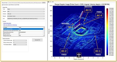
RF Channel Modeler software-generated target-embedded SAR data for AI/ML algorithm validation
Discover Everything That RF Channel Modeler Software Has To Offer in 2024
We’ve touched on important highlights here. If you’re new to RF Channel Modeler software, however, you’ll want to check out these high-fidelity wireless channel modeling resources for more in-depth information regarding its capabilities and applications. And join us Aug. 6 to 8 at the Space & Missile Defense Symposium in Huntsville, Alabama.
The Advantage Blog
The Ansys Advantage blog, featuring contributions from Ansys and other technology experts, keeps you updated on how Ansys simulation is powering innovation that drives human advancement.
