-
-
Access Free Student Software
Ansys empowers the next generation of engineers
Students get free access to world-class simulation software.
-
Connect with Ansys Now!
Design your future
Connect with Ansys to explore how simulation can power your next breakthrough.
Countries & Regions
Free Trials
Products & Services
Learn
About
Back
Products & Services
Back
Learn
Ansys empowers the next generation of engineers
Students get free access to world-class simulation software.
Back
About
Design your future
Connect with Ansys to explore how simulation can power your next breakthrough.
Free Trials

The importance of the oceans is a common denominator in our daily lives, even if it may not be obvious initially. “Nine out of 10 things that you see in your living room have made a voyage in the oceans,” says Gaurav Seth, co-founder and CEO of PierSight. Seth is serious about the importance of Earth’s oceans. His company aims to bring visibility to all human footprints at sea to protect the environment and make maritime commerce more efficient.
Protecting the ocean is no easy task, with a variety of threats — from piracy to blockages impeding global trade — spread across the oceans connecting our world. One pressing challenge that we face today is oil spill detection. Oil spills cause environmental emergencies that greatly affect both nature and the people whose livelihoods rely on their environment.
Detecting oil spills as rapidly as possible is imperative in responding quickly and minimizing their damaging effects, including biodiversity, habitat loss, and harm to local economies and human health.
A rapid detection and response process is also required to meet the challenges of exclusive economic zone (EEZ) monitoring. EEZs contain vast swaths of ocean that require vigorous monitoring to avoid many different threats, including illegal, unreported, and unregulated fishing; human trafficking; and terrorism.
To address these issues, countries need a method of monitoring that is accurate, constant, and able to cover a large area. In other words, we need a method for persistent surveillance in the maritime industry. PierSight’s solution to this challenge? Protecting the oceans via a solution located in the stars: satellites.
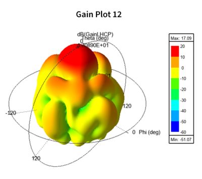
Gain plot showing the gain and radiation pattern of an antenna
Why SAR and AIS Satellites are the Key to Persistent Ocean Monitoring
The secret to PierSight’s vision of persistent surveillance for the maritime industry is the combination of synthetic aperture radar (SAR) and automatic identification system (AIS) satellites.
As a simple explanation of how these technologies work, Seth first describes AIS as similar to an app on your phone that can share live location information. In the maritime industry, AIS satellites pick up location signals tied to a unique ID to identify the location of marine vessels. However, AIS alone is not a complete solution, as malicious agents can turn off their AIS signal or try to fool the system into recognizing that they are in a different location.
To tackle this shortcoming, the maritime industry uses Earth observation (EO) technology to create images of Earth’s surface that confirm the locations of ships and other points of interest. But even with this, it is challenging to maintain persistent surveillance at night or under certain weather conditions, such as storms or heavy cloud cover.
“That’s where SAR comes in,” says Seth. “Imagine a camera with a flashlight in space … ensuring that you detect ships as soon as they go dark.” This metaphorical “flashlight” used by SAR satellites represents radio waves that capture variations in surface properties instead of the optical imagery captured in a photo. Such radio wave imaging is not impeded by darkness or weather conditions.
SAR satellites can constantly image the oceans, process the data in space, and then communicate with relay satellites to downlink locations of interest, such as vessels with turned-off AIS or a potential oil spill. After this, existing EO satellites can take high-resolution images to provide further information if necessary.
Using SAR and AIS satellite technology, PierSight aims to aid the maritime industry by providing all-weather imaging with low- latency data processing, seamless data fusion, and 100% ocean coverage. To do so, the goal is to form a complete 32-satellite constellation that can provide suitable, persistent, and comprehensive surveillance — all while minimizing satellite size and cost.
“We want to build this technology in such a way that it is affordable and mainstream for the vast commercial masses,” says Seth. To achieve this affordability, PierSight focused on designing satellites for their specific maritime application area, which reduced their constraints. “Then, we innovated in terms of the system design and technology and have been able to create the world’s first SAR in a CubeSat form factor,” says Seth. “We can now produce these at a very low cost and proliferate them rapidly.”
Also aiding this cost-efficiency is the fact that PierSight’s technology is designed with the future in mind. Its satellites employ software-defined radar, enabling it to update its firmware for new generations of its technology without having to launch an entirely new satellite. In parallel with this technology, PierSight is also building a downstream application platform for customers that will provide actionable alerts and insights.
Although PierSight’s goals are as clear and consistent as its product, achieving them is no simple endeavor. For one, space is a resource- intensive industry, with products traditionally taking a long time and a great deal of funding to actualize. Attaining these resources and proving your vision with such a long lead time can also be difficult. Additionally, space is a ruthless environment. “Even if only a single thing goes wrong, all your good intentions and hard work can be killed by space,” says Seth. To address these concerns, PierSight turned to Ansys simulation software.
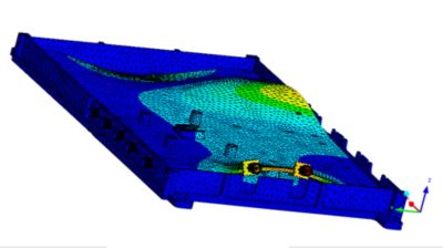
Simulation of a deployment structure for the marginal study at flight loads
How PierSight Uses Simulation Software to Advance an Industry
“Simulation is something very important,” says Seth. “In order to do precise engineering, you need to do precise simulations before that.”
For example, PierSight was able to accurately visualize its mission and its satellite’s thermal performance in the space environment by using Ansys Systems Tool Kit (STK) digital mission engineering software.
This is incredibly important to predict because, as Seth says, spacecraft can experience a temperature gradient of a few hundred degrees over a very small area, depending on the area’s position in relation to the Sun. With STK software, PierSight was able to generate the Sun planet vector data and study its effect on designs.
STK software can also predict the potential coverage of a future satellite constellation, which is an important concern for PierSight’s customers. Let’s say a customer wants to ensure that its full EEZ is covered and that it can receive data at a certain frequency. With STK software, PierSight can simulate the constellation before it even launches to accurately predict coverages and data frequency for a specific time and EEZ in the future, as well as create a visual example for the customer.
The PierSight team also used Ansys HFSS high-frequency electromagnetic simulation software and the Ansys Workbench simulation integration platform to design the antennas in its spacecraft, including the deployable antenna design that PierSight has already launched.
These antennas need to withstand intense vibrations, so PierSight used simulation to analyze antenna performance before moving on to what Seth calls “really ruthless” physical vibration tests, which included subjecting the three-panel antenna to 1,500 G of shock.
When comparing its simulation and real- world vibration tests, the team confirmed that the results matched, demonstrating the reliability of the Ansys software results.
Simulation results help PierSight “gain confidence before a difficult environmental test for space,” says Seth, which also helps to increase efficiency from an engineering perspective.
Exploring the Financial Benefits of Simulation Software
As for PierSight’s financial goals, using the Ansys product suite helps here as well. “For a startup like us who has one shot for success, no matter if the world believes in your theory and loves that you want to protect the oceans, it’s still a challenge to get the capital even for a single shot,” says Seth. “In order to ensure that you don’t fail at this one shot, simulations come to your rescue. So, it’s very important to simulate every single thing.” Further, PierSight was also able to save costs by receiving this software at a discount via the Ansys Startup Program.
In these ways, PierSight used Ansys simulation software to help it achieve both engineering and financial success. But that’s not where the achievements end — PierSight’s designs have already demonstrated real-world value through the Varuna mission.
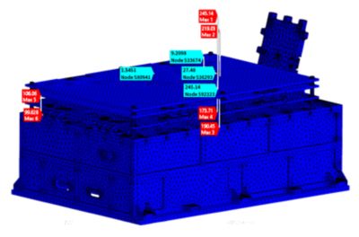
Package-level modal analysis to understand the vibration characteristics of the electronic packages
Modal analysis matching in parallel axis (Y direction) to feed with tested frequency
Simulation Helped PierSight Go From Concept to Launch in Nine Months
PierSight’s goal of transforming the maritime industry is already becoming much more than a vision. On Dec. 30, 2024, PierSight’s Varuna mission — which is acting as an in-orbit demonstration of SAR in a CubeSat form factor — launched aboard a polar satellite launch vehicle (PSLV) on the Indian Space Research Organisation’s (ISRO’s) PSLV Orbital Experimental Module (POEM) platform.
Besides using this mission to move toward a higher technology readiness level (TRL), Varuna showcases PierSight’s ability to move incredibly rapidly as a company — for example, the satellite used in this mission was built in just nine months. With the normal industry cycle for creating a SAR satellite prototype being around 48 months, this shows an impressive 81.25% decrease in time spent.
Even more remarkable is the fact that the team was also developing itself during these nine months, having started with just two members at the zero-month mark. Here, simulation software was a boon for the growing company as well. “With simulation software, even without having all sorts of deeper expertise, you can still get the problems solved,” says Seth.
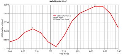
Axial ratio plot showing the polarization purity for the circularly polarized antenna
Seeing a Bright Future for the Maritime Industry and Beyond
Varuna is just the start of PierSight’s bright future. Its next commercial satellite, which is planned to launch near the end of 2025, will usher in the start of its commercial operations. Seeing these commercial satellites launch and form a constellation will signal major success for the company by fully enabling it to generate and share data that can solve customers’ problems. A couple of these solutions include:
- Comprehensive and real-time monitoring to identify oil spills via PierSight’s satellite constellation, better protecting both marine life and humanity
- Persistent monitoring of EEZs to accurately detect illegal fishing, dark ships, and other unlawful activities at sea, thereby aiding private, government, and nongovernmental organizations
These are not the only goals that PierSight has either. Its team aims to take a complete digital mission engineering approach to its work, which will help it work toward its goal of being one of the largest satellite manufacturers globally.
Learn more about how STK software can help with your satellite missions.
"In order to ensure that you don’t fail at this one shot, simulations come to your rescue. So, it’s very important to simulate every single thing.”
— Gaurav Seth, Co-founder and CEO, PierSight


The Advantage Blog
The Ansys Advantage blog, featuring contributions from Ansys and other technology experts, keeps you updated on how Ansys simulation is powering innovation that drives human advancement.